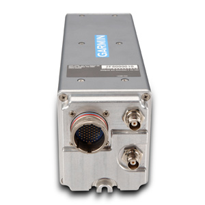
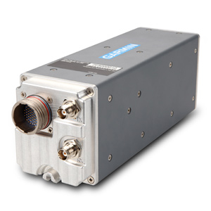
GRA™ 5500
Know How Low You Can Go
- All-digital design provides smooth, consistent readout
- Meets requirements for Class A TAWS and TCAS II/ACAS II
- Meets requirements for CAT II ILS operations
- Highly accurate, rugged and reliable
- Interfaces with Garmin flight displays and 3rd party equipment
With its all-digital design, the GRA 5500 represents the latest and most accurate technology available in radar altimeters. It’s reliable enough to meet the needs of even the most demanding helicopter, business jet, transport category and general aviation applications while being so accurate it can serve as an integral part of your Class A TAWS, TCAS II or CAT II ILS solution.
Discover the All-Digital Advantage
The GRA 5500’s patented digital signal processing technology can intelligently process hundreds of altitude readings every second and filter out anomalies, smooth altitude tracking and crosscheck data and system integrity. These benefits combine to provide a smooth and consistent readout of your altitude Above Ground Level (AGL). The GRA 5500 is designed to work in a multitude of environments, allowing you to go from rough terrain to tree canopies, sand to choppy water and know exactly how much room you have to maneuver. Gain added peace of mind knowing that the radar altimeter is operating normally thanks to advanced, comprehensive self-testing technology that continuously monitors incoming data and system integrity to help assure that the altitude provided is accurate, even in low-visibility conditions. In most installations, this self-testing technology eliminates the need for the pilot to interact with the GRA 5500 in any way.
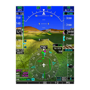
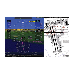
Interface With Your Avionics
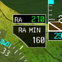
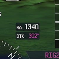
Designed to work with Garmin flight displays like the G500, G500H and G600, the GRA 5500 conveniently puts your AGL readout right in front of you. This display integration, along with its reliability and accuracy, make it an optimal solution for operators equipping for NVIS operations. The GRA 5500 also integrates with the GTS 8000 and GTX 3000 to provide a complete TCAS II system, and satisfies radar altimeter requirements for Class A TAWS systems and CAT II ILS operations. In fact, in many installations only a single GRA 5500 may be required where multiple redundant analog radar altimeters might otherwise be needed. Thanks to patented technology, the GRA 5500 offers a simpler installation that can further provide you with weight and cost savings by eliminating the need for long lengths of antenna cabling that are traditionally required in the installation of radar altimeters.
Physical Characteristics
- Unit Height (with mounting rack): 3.99” (101.3 mm)
- Unit Width (with or without mounting rack): 3.02” (76.7 mm)
- Unit Depth (with mounting rack and connector): 11.62” (295.2 mm)
- Unit Depth (with mounting rack, connector and configuration module): 12.08” (306.9 mm)
- Unit Weight (with mounting rack): 3.5 lbs (1.6 kg)
- Typical Mating Circular Connector Weight: 0.13 lbs (0.06 kg)
- Typical Mating RF Connector Weight (2X): 0.07 lbs (0.03 kg) (weight listed is for 2 connectors)
General Specifications
- Operational Temperature Range: -55° C to +85° C
- Altitude Range: 55,000 ft maximum
- Software Compliance: RTCA/DO-178B Level B
- Hardware Compliance: Not Applicable - The GRA 5500 does not contain any complex or programmable logic devices
- Environmental Conditions: RTCA/DO-160F
Performance Specifications
- Altitude Accuracy: ± 1.5 ft (3 - 100 ft AGL); ± 2 % (> 100 - 2500 ft AGL)
- Altitude Range: -20 - 2550 ft AGL
- Altitude Alert Outputs Range: 0 - 2500 ft AGL
- Altitude Output Time Constant: 0.1 second maximum
- Transmitter Output: Frequency: 4.25 - 4.35 GHz "Gated" FMCW; Power: 1.0 W nominal
- Horizontal Velocity: 0 - 200 knots maximum
- Vertical Velocity: 20 ft/sec maximum (up to 100 ft AGL); 25 ft/sec maximum (above 100 ft AGL)
- Pitch Angle: ± 20° maximum
- Roll Angle: ± 20° maximum (with published altitude accuracy limits); ± 20° to ± 30° (with ± 20 % altitude accuracy limits throughout entire altitude range)
Power Requirements
- Supply Voltage: 14/28 VDC. See the Environmental Qualification Form for details on surge ratings and minimum/maximum operating voltages
- Power Consumption: 13.75 W maximum (0.5 A at 27.5 VDC, 1.0 A at 13.75 VDC)