G3000H™ Integrated Flight Deck
VFR/IFR-capable Integrated Flight Deck System for Helicopters
- Intuitive, centralized data entry and high-resolution glass displays with split-screen capability, HSI mapping and voice-controlled radio selection bring new levels of efficiency to helicopter flight deck management
- Garmin HSVT™ 3-D synthetic vision with WireAware™ technology helps pilots see clearly in nighttime VFR conditions or degraded visibility environments (DVE)
- Obstacle avoidance with available Helicopter Terrain Awareness and Warning System (HTAWS) features five-color display shading and audible voice callout alerts for enhanced terrain awareness
- Flight Stream 510 adds connectivity with a compatible mobile app for flight plan transferring, Database Concierge and more
- Offers optional night vision goggle (NVG) compatibility and multiple video inputs for tail-cam, FLIR or other optional camera displays on multifunction display (MFD)
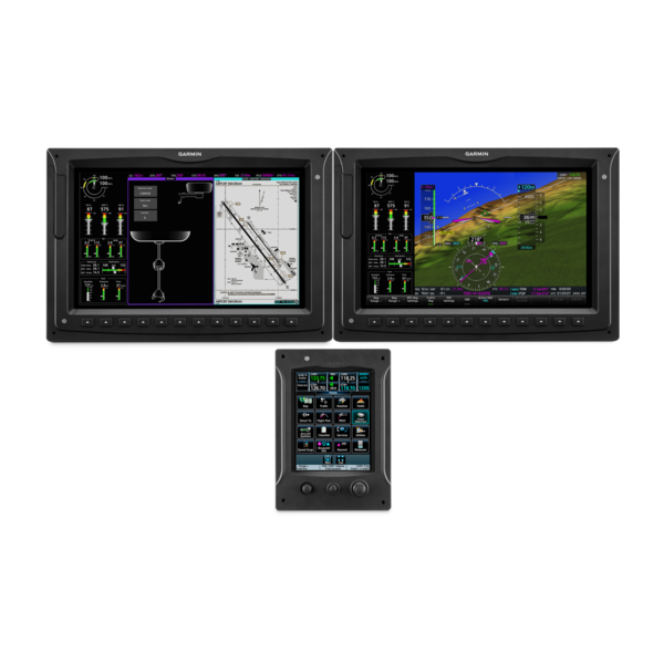
For helicopter operators who want the “best and brightest” in integrated flight deck systems for the next generation of VFR/IFR-capable Part 27 airframes they’ll soon be flying, the G3000H integrated flight deck is right on point. Featuring large, high-resolution displays, centralized touchscreen controls and a streamlined user interface with familiar “app” style menu icons, G3000H brings a new higher level of performance, efficiency and situational awareness to helicopter cockpits.
Touch-and-go Control
Featuring integrated system management via 1 or more 5.7” touchscreen controllers at the pilot positions, G3000H centralizes data entry to help eliminate wasted motion and allow more functions and sensors to be accessed with fewer keystrokes. Responsive, icon-identified “touchkeys” make functions easy to locate — providing fingertip access to full GPS/Nav/Comm radio management and page navigation as well as checklists, charts, mapping, flight plan entry and remote audio/intercom and transponder selections. Additionally, access to a wide array of optional weather, traffic, inflight entertainment and even cabin environmental systems can be supported through the touchpad console as well. Dynamic single limit indicators are supported as well as hover performance and Category A calculations. To further streamline pilot workflow, our available Telligence™ voice control technology enables certain functions, such as radio selection, to be activated via spoken commands, so pilots don’t need to lift a finger from the controls when things get busy in the cockpit.
Large-format Glass Flight Displays
From a visual perspective, the bright, crisp G3000H flight displays offer unprecedented situational awareness for this class of electronic instrumentation. The 12” diagonal, high-resolution screens are driven by ultrafast processors that deliver the power for robust map graphics with highly responsive zooming, panning and updating. Each screen can function independently as either a primary flight display (PFD) or an MFD — or in reversionary mode as both. On the large PFD there’s ample room for the simulated 3-D landscape of Garmin HSVT synthetic vision technology as well as enhanced peripheral cues from an extended horizon line.
Likewise, over on the MFD, the larger format enables pilot-selectable split-screen functionality so that 2 separate page views can be viewed simultaneously on the same screen. This vastly expands the amount of graphical information that can be viewed at once — virtually enabling 2 displays to do the work of 4. Thus, pilots are able to select and scan more critical information at a glance, without having to flip through multiple pages in sequence during time-critical phases of flight. Split-screen capability makes the G3000H MFD even more multifunctional — supporting selectable displays for electronic charts, approach plates, traffic, weather, TAWS alerts, flight planning pages, inputs for FLIR, tail-cam or other livestreaming video sources, satellite-linked text messages, incoming call alerts, smart notifications and much more2.
Flight Planning Made Simple
Even before pilots arrive at the airport or helipad, G3000H is working to simplify and streamline their workloads. With the addition of an optional Flight Stream 510 wireless gateway in the aircraft, pilots can use compatible mobile devices running the Garmin Pilot™, ForeFlight Mobile or FltPlan Go apps to preplan their missions — and then wirelessly upload their flight plans into the avionics once they’re onsite. Flight Stream 510 also enables a wireless Database Concierge connection to automatically upload the latest database updates to the system. This app-to-avionics interface saves valuable time once spent on tedious in-cockpit data entry — so pilots can quickly complete their preflight checklist items and be ready for liftoff sooner.
Aids to Getting Airborne
Ground ops prior to takeoff can go a lot more quickly with the G3000H flight deck. As pilots prepare to call for clearances, they’re able to select the active frequencies from the airport information pages. The frequency is automatically entered and identified on the PFD. Then, it’s a simple matter of checking the MFD airport diagram for current taxiway and runway traffic. The expanded G3000H suite of Garmin Terminal Safety Solutions™ includes SafeTaxi® diagrams with TerminalTraffic™ surveillance of ADS-B equipped aircraft and vehicles operating within the airport environment. Optimized for helicopter operations, the TerminalTraffic display is designed to keep “nuisance” alerts to a minimum — while maintaining pilot awareness of potential traffic conflicts on and above the airport surface. Thus, alerts from nearby fixed-wing aircraft are minimized and abbreviated when your helicopter is hovering or performing other unique maneuvers. To limit audio interruptions in the cockpit, these tailored alerts are accompanied by an aural “traffic” message when your helicopter is operating below 40 knots and 400’ AGL.
Departure and Climbout
With checklist completed and takeoff clearance received, it’s time to crank up the power and get airborne. In busy terminal airspace, a pilot will especially appreciate the G3000H flight deck’s HSI mapping capabilities that put an MFD-like perspective map right in their primary field of view within the HSI portion of the PFD. In addition to the geographical map, the HSI map view can also support the overlay of NEXRAD imagery and weather inputs from ADS-B, SiriusXM® and Iridium® datalinks. Additional overlays include SafeTaxi airport diagrams, traffic, terrain and more.
Within the display, any towers or obstacles that may encroach upon the flight path are color-highlighted and clearly depicted with height-appropriate symbology. And for added visual reference in low-level operations, our WireAware technology overlays power lines on the displays to help pilots recognize potential wire-strike hazards in proximity to the aircraft’s flight path.
En Route Navigation
In addition to the geographical map overlay within the HSI, Garmin HSVT synthetic vision technology comes pre-installed on G3000H. Using sophisticated graphics modeling, this technology recreates a 3-D “virtual reality” database landscape with terrain, wires, obstacles, airports and other details displayed on the PFD. Also, there’s a useful projection of the aircraft’s flight path, indicated by a flight path marker on the HSVT display, which shows the calculated effect of variables such as attitude, airspeed, wind vectors, etc. on the aircraft’s trajectory across the ground. It’s a useful tool to have when trying to gauge a possible conflict with terrain or obstacles near your flight path. It also aids in targeting the helipad or runway threshold on approach, particularly when correcting for crosswinds or low-level turbulence. HSVT clearly enhances the pilot’s view of primary flight data by giving it a realistic visual frame of reference — especially in solid IFR or nighttime/marginal VFR conditions.
For on-screen map and chart navigation, the G3000H system’s dynamic moving map display on the MFD can also be supplemented with helicopter-specific charts throughout 8 U.S. metropolitan areas, including the Gulf of Mexico and its oil drilling platforms — as well as VFR sectional charts, IFR en route charts, electronic approach plates and previews of standard airport departure and arrival procedures.
Supporting Safe Separation
For added hazard avoidance, G3000H supports high-resolution, five-color HTAWS alerting. Using high-integrity GPS position information, compared with the the system’s internal databases, the HTAWS offers “forward-looking” avoidance capability to predict in advance where potential hazards may exist — thus helping pilots maintain safe separation from nearby terrain, power lines, towers or obstacles. Accompanying voice alerts also indicate the relative threat level with messages such as “Caution, Obstacle, Obstacle” or “Warning, Terrain, Terrain” — as well as tracking your aircraft’s height above ground when descending below 500’. When your mission requires operation in close proximity to known terrain or obstacles, a pilot-selectable reduced protection (RP) mode serves to minimize alerting interruptions.
Also, to help pilots keep their eyes peeled for traffic, the G3000H system supports ADS-B “Out” and “In” functions that include our patented TargetTrend™ relative motion technology. This offers a faster, more intuitive way of judging target trajectories and closure rates relative to your aircraft’s flight path. For even more capability, G3000H is compatible with a variety of active traffic systems2.
Weather-watching Technology
Weather conditions can change quickly while en route, so G3000H also offers pilots a variety of datalink options — showing animated NEXRAD imagery, current airport conditions, forecasts, precipitation, lightning, winds and more. In the U.S., both the ADS-B network and SiriusXM satellite weather services¹ can be accessed from the system (SiriusXM subscription and optional hardware required). Plus, an optional Connext® satellite link receiver can also bring seamless on-demand worldwide weather information to your cockpit for international operations. For tactical onboard weather avoidance, an available Doppler-capable digital radar² enables full-color storm cell imagery to be overlaid on the MFD’s moving map — as well as on the PFD’s HSI map display.
Descent, Approach and Landing
As your flight nears its destination, the G3000H flight deck works to streamline and simplify the transition into arrival and landing. At a glance, G3000H gives pilots a clear picture of the aircraft’s horizontal and vertical flight situation. For added context, a vertical situation display (VSD) on the MFD provides a georeferenced profile view, which looks much like the bottom portion of an approach plate, showing the descent in relation to nearby topography as well as to the active flight plan. The built-in SBAS/WAAS-certified GPS receiver allows you to fly GPS-guided LPV glidepath instrument approaches, greatly expanding your operational capability. The system also includes a complete package of VHF navigation capabilities, with VOR/ILS with localizer and glideslope. Plus, G3000H goes even further by adding Visual Approach capability. When operating in VFR conditions, G3000H can provide advisory vertical approach guidance based on a published glidepath angle or a 3-degree approach glideslope from the runway threshold, while considering terrain and obstacle clearance.
Continuing through the landing procedure, georeferenced SafeTaxi diagrams help the pilot stay oriented if they’re not familiar with airport layout. The pilot can easily navigate the georeferenced layout of runways and taxiways, drop onto the destination ramp and begin clicking through the shutdown checklist. Meanwhile, a built-in Flight Data Logging feature automatically stores all critical flight and engine parameters on an SD™ data card, which your service crew can use to analyze trend information and spot early signs of potential service issues to help avoid more costly repairs later.
Confidence Without Compromise
Like all Garmin integrated avionics, G3000H is designed with today’s — and tomorrow’s — most advanced technologies in view. Not only can you count on these growth-oriented displays to keep pace with evolving airspace and operational requirements, but you’ll know you’re flying with the peace of mind that comes with a rock-solid 2-year warranty (and optional FlightLevel Extended Warranty), backed by the industry’s most acclaimed avionics product support team. Garmin G3000H: It’s clean-sheet helicopter technology, built from the ground up.
¹Additional equipment and/or subscriptions may be required
²Capability may be optional or not available on all aircraft